Friday, June 29, 2012

Solomons

Friday June 29
38 19.946N
76 27.434W

Big Day

Yellow X marks the spot
41 miles today - that's a big day, but we wanted to get to Solomons to have Saturday to prepare the boat for visitors. Turns out its a good thing we did not anchor out and came to a dock in a protected area. - there is a giant row of thunder storms heading our way - I am watching it on the radar. It has already knocked the power out in 60,000 residences in the DC area.

Our trip today was rather straight forward - out into the bay and north for 30 miles or so without a navigation change. Now we are in the Chesapeake we are learning to share the sea with big ships as the main channel is over 80' deep, and there are some big ports up north - Baltimore for example. In the last few miles we navigated into the XXX River and then into the creeks that make the inner harbor of the Solomons. We were well protected and secured to a new and solid looking floating dock.

We watched the storm arrive on our radar. There was a line of "purple and red" thunderstorms that was 100 miles long and 50 miles deep, travelling east at 60 MPH. We had stripped the vulnerable parts of the boat and tied down the rest well before it arrived, and a good thing too. When it hit us the wind was from the starboard forward quarter, and it was so strong it made the boat sort of kneel over, forcing it into the dock. I prowled around out side, adding bumpers and catching items as needed. The bar-b-que cover blew off, but I speared it with a boat hook and recovered it. One of the bike bags broke lose, but we could that as it was sliding over the deck. The harbor was a "maelstrom" with boats dragging (we did not see but were told) and furled sails being stripped of fore stays - makes a lot of noise! It was over for us in about 45 minutes. But the damage on land was quite severe - several days later there are still over a million people without power. The dock power only flickered a few times.


Launching the dinghy
Hooking up the hoist
This is quite a procedure so I thought it would be fun to document. It takes us about 30 minutes to launch and to recover, so we tend not to do it unless we are staying in one place more than overnight.


Cover off, hoist connected


Up and out


I get the easy bit


Thursday, June 28, 2012

Ingram Bay, Sandy Point

Thursday June 28, 2012
37 49.421 N
76 18.890 W

Another great anchorage - we are starting to like the Chesapeake! Yesterday we made arrangements to spend tonight at a private dock in the Little Wicomico River. When making our float plan we had noticed that the entrance looked a bit dicey, so we called our host to check. He told us "No probs" and so off we went his morning.

First Swim
We arrived at the opening about 3PM and made a valiant attempt to get over the shoal but when the depth under the boat was down to 12" we chickened out. We had called our host several times for "local knowledge" but our calls were going to voice mail. The weather was also deteriorating, as forecast, so we changed plans and headed back south 10 miles to Ingram Bay, where we had back up anchorages. And here we are. Even had a swim.

Bill Mikler has heart surgery today. I feel a long way away. I am sure it will go well. We are waiting for a post op call from Tonni.

Sue and Bruce will join us in the Solomons on Sunday. We are very excited. It will be fun to have friends on board. We had planned to take a slip at the marina for the whole weekend, so we could get prepared, but they are booked till Sunday. So tonight we will make "Plan B".


Tuesday, June 26, 2012

Deltaville

Tuesday June 26, 2012
37 32.341 N
76 20.077W

We are right in the middle!
We are getting better at finding anchorages. After a rather rough passage, this place is a gem.In fact, its so nice we have decided to stay two nights. This is a satellite image that Bryce sent me. The anchorage is protected from all directions except south - there is about 2 miles fetch from the south, so even that is not too bad. Nice houses with neat lawns all around, a small marina to the west.

Yesterday's passage was a bit bumpy. It was a sunny day, but the wind got up to 20/25 MPH with some stronger gusts. It was a northerly, so we were heading right into it most of the day. I thought Tide Hiker handled it well, though the bow did tend to go "up and down a bit". Deidre did not put on her life jacket, so it could not have been that bad. Biggest problem was that we had "corn on the cob" for lunch and it rolled around in the microwave and then on our plates as we tried to eat it.

Wolf Trap Light
We went past a shoal called "Wolf Trap". (That may not ring any bells in Australia, but it is also the name of a well known outdoor theater here - think "Meyer Music Bowl"). Well, it is originally a shoal in Chesapeake where the British navy ship "Wolf" sank back "in the day" and now the sight of a caisson style light house build in the early 1800's. We did not get too close, and our camera is not too great, but here is a photo.


We will resume our northerly trek in the AM. Our immediate objective is to get to a marina in "The Solomons" by Friday night. Our friends Bonnie and Jon are there, plus we are planning to meet up with Sue and Bruce at the marina on Sunday, and spend a week together on board.

Close the windows!

As previously mentioned, the weather on Tuesday was a bit rough, but Tide Hiker did well. The crew on the other hand......

We have become so comfortable with placid weather over the last few weeks, that we forgot to close the port lights on the bow. They look into the V berth. Deidre popped down to use the jon mid afternoon Tuesday, to discover that "waves are breaking thru the port lights in the bow, and the V berth is sodden!" So first job in Fishing Bay was to drag out all the bedding, the carpet and the clothes in the top drawers to dry in the sun or go into the wash. What a lesson. So today they were screwed down!


Sunday, June 24, 2012

Old Yorktown

Sunday June 24, 2012
37 14.037N
76 29.980W

Foot Therapy
My recollection is that some evening a week or ten days ago, Deidre and I were both bitten on the feet and ankles by some aggressive mozzies. It was not much of a deal then, and typically I am not affected much by insect bites, but since then all 4 of our feet have become quite unhappy. We find ourselves tearing at our feet with our nails plus a variety of other implements (such as the scrubbing brush, Brillo pad etc) randomly through day and night. It was getting to the point that I was thinking "medical advice" because our feet were swollen and there seemed to be risk of infection. I  yearned for some clean salt water, and last night in the York River we had that opportunity. So last night and this morning we sat on the swim platform and soaked our sore feet. I feel better today, we will see how we progress from here on.

Sunset
We are currently secured to a mooring ball off the "beach" at old Yorktown. This is a very historical place in the USA - primarily because this was the location of the last and decisive battle with the Brits in the Revolutionary War. It also had a role in the Civil War - probably for the same strategic reason. We arrived about 2 PM, we are "chillin" right now, but when the mood strikes us we will launch the dinghy and go ashore.

It was a calm night and we slept well.


Monday, June 25

We launched the dinghy last night, taking advantage of the calm.

We enjoyed our breakfast on the aft deck and then ventured into town about 10 AM. The Marina Manager (Mike) met us on the dock and we signed in and paid, and he told us all about the town and its facilities. We asked about a drug store, as Deidre needed to refill her prescriptions. Apparently it was a few miles away, but he generously offered to drive us in his personal car. We accepted and Deidre got her pill supply and I did some shopping at the supermarket next door.

Sorting out the outboard
We ran the shopping back to the boat, and a good thing too. In our absence someone had probably "waked us" and as a result the refrig doors had burst open and dumped much of the contents on the floor. We cleaned up and then jumped back into the dinghy to go back to town, only to discover that the starter on the outboard motor was making a terrible noise. So Deidre climbed back on the boat to make lunch and I investigated the noise. Turned out the starter motor mounting was lose and the Bendix gear was not making proper contact with the fly wheel, and just needed to be tightened.


We headed back to town after asparagus tips in fresh bread, washed down with a nice crisp Pino, sitting in the shade on the aft deck. (Retirement is definitely fun.) 


We had noticed that a decent sized warship was coming up the river and surmised that the bridge would have to open. So we stooged around in the dinghy to watch and take some photos. The bridge is the largest opening bridge in the USA. The warship was escorted by a couple of patrol boats, and there was two large tug boats waiting for it at the bridge.

Turned out that there was an ammunition pier just north of the bridge. No smoking!


The town provided a "Lolly the Trolley" for the tourists so we took a ride around the town and the battle fields, visited the Visitor Center (watched a movie) and the Victory Monument, where this photo was taken. The town itself was as neat as a pin, with many buildings dating from the late 1600's and 1700's. We were able to take a photo of Tide Hiker from the bluff. Such a sturdy looking craft!


ADAKY surrounded!
   When we got back to the marina our little dinghy was surrounded by the Coast Guard. We wondered if we had paid too much attention to the war ship, took too many photos? How much trouble were we in? But it looked like there was a storm brewing and we did not want to mess around with the Coast Guard. So we fronted up like we owned the place - turned out they were "in port" for lunch.


We were back at the boat none too soon, because a violent thunderstorm arrived within minutes. The water went from placid to a maelstrom. It really had our attention for about 45 minutes but then it was over. The water is flat as a mill pond again.

We are fortunate that Tide Hiker seems to deal with weather pretty well. Other boats seem to bounce around a lot more that we do. I suspect the fact that she is big and heavy - 35 tons? - helps a lot.


Poquoson River

Saturday June 23, 2012
37 09.165 N
76 24.875 W

The marina manager ("Brian") sought us out yesterday (as we were headed to the super market) to tell us they had just reduced their diesel price 30 cents to $3.359 gallon. They had been really good to us - we had slap up dinners for two nights at the marina restaurant but paid no marina fees - and this was a good price for fuel, so we decided to "fill 'er up". This would be the second time we had filled the tanks, so it would also give me an opportunity to calculate our "fuel economy". We took on 290.256 gallons and I calculated our fuel consumption per hour at 4.38 gph (including generator use). This was a bit disappointing, I had hoped to be somewhere in the "3's".  


First Bridge for the day
We were on our way at 10 AM, targeting the 10:30 AM opening at the next bridge. Talk about a change in scenery - from swamp to commerce, industry and war. The 10 mile cruise through Norfolk and Hampton Roads was busy and very interesting.  This was where many of the convoys assembled during WW 2, and it easy to see why. It is still a huge navel base. 


"Pods" of Destroyers
My goodness we must spend a fortune on the military. The number of ships and facilities in the area is enormous. Talk about the "military-industrial complex". We passed a series of wharves with 4 destroyers per wharf - I counted 16 destroyers in a row. We also saw a large aircraft carrier, a nuclear sub, a whole fleet of "roll-on roll-off" ships from the cold war era, floating docks etc etc. There is not room to put in all the photos. 

Three Roll-on Roll-off ships ready for WW 3
We had to dodge a few ships and barges as we headed through "The Roads" and out towards Chesapeake Bay. There was a fair in a downtown waterfront park and that added a bit of color to all the "Navy gray". It was a sunny day with a bit of a breeze, so the whole experience was pleasant. Once we cleared the main channels we headed North up the East shore of Chesapeake towards the Poquoson River. It was about 15-20 miles and a pleasant ride. We were tucked into a corner in 10-12 feet by 4pm.

The breeze died. It was hot and our feet were itchy. We tried the aft deck for relief in the shade, but it was just too hot. So we closed up the boat and turned on the AC and stayed like that all night.


Aircraft Carrier


Navy floating dock 

Friday, June 22, 2012

Chesapeake City, Virginia

Chesapeake City
36 44.373W
76 17.770W

It's now 4PM on Friday and I have had enough time to recover and update the blog. Today was a good one, but long, hot and challenging at times. Turns out the day's max temperature was an all time record for the date, and we were in a swamp.

Wednesday night we had anchored "behind" Goat Island on the Pasquotank River, a few miles upstream from Elizabeth City. We felt like we were in the Amazon, dark brown water, trees and growth choking the waters edge, lots of water birds and millions of bloody frogs at night. But when you look at the satellite photo, there was plenty of "civilization" close enough. But it did not feel that way Wednesday night. I did not want the boat to sink.

We had the AC on while we had dinner and cleaned up, but I hate the sound of the generator so shut it all down when we went to bed. It cooled off a bit after dark (which is about 8:30PM - today is the longest day of the year up here) and we both had a decent night's sleep. We had to be up a bit earlier next day because we wanted to get to the first lock for the 11.00 AM service. (Next one at 1:30 PM)

Recovering the anchor was a real treat. The chain was 100% coated with black, sticky mud. By the time we had the chain in the locker the fore deck looked like a mud wrestling pitch, and I did not look much better. But we are getting expert at recovering the anchor and we were on our way on schedule.

Having entered the lock
The first lock was fun. The Dismal Swamp canal was dug by slaves, starting in 1793, taking 12 years, and is about 22 miles long. God only knows how many must have died as the canal bisects a swamp.

The locks have been rebuilt 5 times, the current locks were built in the 1930s. The lock tender explained the mooring system he wanted us to follow over the radio as we approached. There was only one other boat in the lock with us (They passed us as we were recovering the anchor earlier that morning.) Tide Hiker and crew passed with flying colors - and with no scratches. The lock lifted us about 8 feet and we were on our way into the old canal.


Into the canal
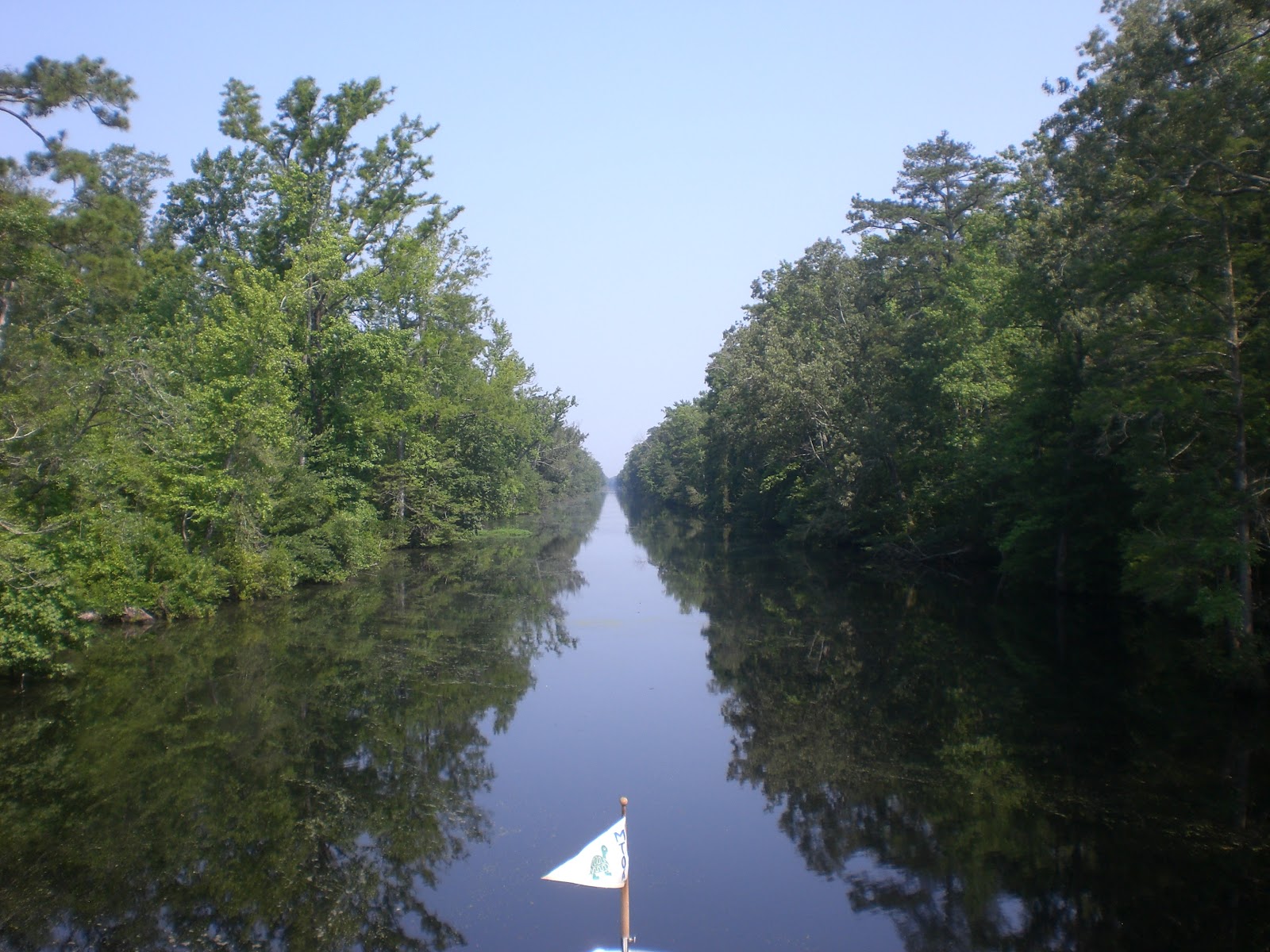
The water in the canal was like glass and it reflected the trees and scrub that overflowed from the waters edge. At times it was hard for me to see where the surface was. It felt like the boat was suspended in air in a forest. It was quite weird. After we left the lock the channel became quite narrow, maybe as little as 50'. We typically had 2 or 3 feet of water under the keel, but the floor of the channel was choked with waterlogged trees, and every now and again we heard and felt "thump, thump, scrape" as the keel slid over a tree trunk (or worse?).


It was quite interesting for a while. But it was also getting hotter and more humid. Plus there was a speed limit of 5 MPH. Plus the biting bugs were out in force. Deidre stuck it out on the bridge for a while, but then started feeling faint retreated below into the AC. I stuck it out at the helm, cold drink in one hand, fly swatter in the other. We could only travel at 4 or 5 miles per hour because of the speed limit, the obstacles and depth. The hours dragged on. We saw a snake swim across. Enough of the Dismal Swamp! We crossed into Virginia at Mile 17.

We were 30 minutes early for the second lock, so tied up to a bulkhead - no scratches. The lock tender called us when he was ready at about 3:30 PM, and we repeated the process. No scratches. And we were out.

All of a sudden we were transferred from primordial swamp to industrial America. We were alongside a freeway, needed to give way to a barge, concrete plant on one shore, oil refinery on the other....but no bugs... hallelujah! We decided that we needed (and deserved) a marina for the night and found the right deal! At the Top Rack Marina you can work off your dockage ($65, very reasonable) in the restaurant! But as we approached the heavens opened with one of those thunderstorms you experience after a really hot day - it was raining cats and dogs and blowing like a hurricane, just as we arrived. I missed the approach 3 times and had to back off, but the "4th time was a charm", no scratches.

I think she enjoyed getting wet.
Deidre had been directing from the deck and was drenched. This photo does not do here justice. She told me that her nickers were even wet (But maybe from the excitement of my 3 missed approaches?)  I think she was happy because it was the first time she was cool all day.

We enjoyed a great nosh up in the restaurant that night and have decide to stay another day and do the same Friday. (It's great, we did not bring the bathroom scales with us!)

Friday June 22

The marina seems to be in an industrial area. There is a cement plant across the river and a lot of barge traffic. The nearest super market was a few miles away so we called them and they agreed to pick us up. The larder was down peanut butter on crackers. (And we both needed something for the bites on our feet!) We spent $250 at the market, but got a newspaper!

Our marina was primarily a dry storage marina, and we were moored right next to where they launched and recovered the boats. It was fun to watch. The lift trucks were enormous and lifted quite large boats in and out of the water with ease.

It rained cats and dogs again on Friday night, and this time the wet weather lasted several hours. Most of that time we were back in the restaurant spending our $75.00 on lobster bisque, crab cakes, a nice dry Italian Pino and fresh bread. All right!


Wednesday, June 20, 2012

Goat Island

Wednesday June 20, 2012
36 20.771 N
76 13.527 W

We are anchored at Goat Island on the Pasquotank River - at least for now. So far this afternoon we have tried to stay at a marina, a free dock and attempted to anchor 3 times. And I scratched the boat. We are hoping that this "third try is a charm". Its bloody hot, so we have a generator running and the AC blasting. Let's hope this anchorage lasts. I have my doubts, the bottom felt very soft and gooey.

We had a good night's sleep on the Alligator River. Following the usual morning routine we were underway at about 9:30 AM and through the swing bridge into the Albermarle Sound within the hour. The "crossing" took about three hours and then another couple of hours up the Paspoquank River to Elizabeth City.

Elizabeth City has the reputation as being cruiser friendly. The city provides a bunch of free docks for cruisers to use and arranges regular "wine and cheese" dock parties for the crews. Some times even the mayor comes down to visit the cruisers and free rides can be arranged for shopping trips etc. All sounded great.

We had a look at the free docks and were not too impressed as they looked small and we would need to back in. So we decided to try a "very reasonably" priced and "friendly" marina. We called them on the radio and they guided us to a slip. Well, it turns out a 35' boat might have been secure, but our baby's big ass was hanging out into the river and there was no way for us to get off the boat. Just crazy, and just not for us. So we excused ourselves and backed out "no hard feelings". It was tight, and I hit a pylon backing out. Shit, scratch #1.

So we headed back over to the free city slips. There was a bulkhead that looked OK, so in we went. There was no one there to meet us, so we were planning to put the boat alongside - the wind was in our favor - and I was going to jump ashore to take lines. The wind was blowing us in, so I figured it would work. Well, it did not, and I scratched the boat again.

Anchoring was the next choice. We went thru the lifting bridge and tried to anchor in the pool next to the bridge. It dragged. So we headed further up rived to another spot. We dropped the anchor twice and it dragged both times. Each time we recover the anchor ii came up covered in slime, so has to be hosed off each time. Our deck was looking like a building site. So we tried this spot and so far so good, but I am not convinced. Fingers crossed that the wind does not get up during the night.

There is another issue. Apparently the area is renowned for underwater tree stumps that grab anchors. So we have to drop the anchor with an extra line on a float that is attached to its head. If the anchor gets caught on a stump, the idea is to use the extra line to pull it out backwards. That's the theory.

Other than all the drama - its a beautiful spot. We could be in the Amazon. No sign of civilization, just water, big trees and deep and dark looking water. Its hot and still.

Tomorrow we are off to the Dismal Swamp - and our first lock!