Sunday, June 30, 2013

Sunset Bay (Day 2)

Sunday June 30, 2013
(Still at Sunset Bay)


Wet pirate ship
Its grey and now its raining. There is only one desperate wave runner (thank goodness) but the pirate boat is out on its route. Good sleeping, eating and blogging weather and it will keep all the holidaymakers off the water.

I have just calculated that Tide Hiker averaged 1.886 gallons per nautical mile since our last fill up. That includes generator use. (For you dirt dwellers, that equals 2.17 statute miles per gallon.) I am pretty chuffed with that result.

We have now made contact with two trawlers heading north up the ICW and I have two phone numbers to call tonight to see how they manage. This section of the ICW is regarded as impassable for boats our size, which is why we are waiting here for decent weather to go outside. Hurricane sandy did more damage and created more shoaling.

Not a wasted day. I have re-installed the wifi aerial (recently returned from the manufacturer) and it is working. I have investigated a small leak in the lazarette and it seems resolved. I have studied the tide for tomorrow and we have a plan to try the ICW to Atlantic City. The weather is getting worse rather than better. It's no big deal because the Erie Canal is closed, damaged by weather. I am starting to think "global warming" has arrived!

We have a plan to leave tomorrow and take the ICW rather than go outside. The NJ ICW has a bad reputation for lack of maintenance and shoaling. Sandy made it worse. So we plan to leave on a rising tide at about Noon and make it to Atlantic City by 7 PM.


Saturday, June 29, 2013

Cape May

Saturday June 29, 2013
38 58.350 N
74 50.676 W

We were up at 5:30 AM and under way at 6:00 AM. The dock master turned up to help us turn the boat around and handle lines - what a good guy - I had been thinking all bloody night about turning a 49' boat in a 70' wide channel with a strong current. We did it with a bow line on the dock and it was a breeze.

Some interesting old lighthouses
We appeared to hit the Delaware at slack and enjoyed the ride as the tide and current did its job.At one point we hit 10.6 kts which is light speed for us. Overall we covered the 49 NM to the Cape May entrance in just 6 hours. The wind picked up after lunch.

Cape May is like Rosebud for New Jersey folk. (Sedona for Phoenix people? South Beach for college kids?) We had arrived on a weekend in the summer. The weather was not great but the water was crawling with just about anything that floated. In general it is probably fair to say that NJ people (like new Yorkers) have little interest in the the COLREGS. (Road rules for the water)

Drifting in the channel
But first we needed to get fuel so we bought 537 gallons at "Miss Chris" marina. Then we headed thru Cape May to what looked like a decent anchorage about 5 miles up the ICW. As mentioned previously, Cape May is a summer "vacation place". There seem to be a million boats with no-one on the same page as us. Tide Hiker has a pretty serious  air horn, and I used it several times to assert our right of way.  If the fish bight best in the channel, then that's where you fish.

We made it to the anchorage. I would describe it as an "urban anchorage". As we arrived we probably disturbed a dozen wave-runners, 1/2 dozen power boats pulling tubers and at least one pirate boat. We could here the music drifting over the water from the waterfront bars and restaurants. Took us two tries to get the anchor to stick (I hope it did). The weather forecast for the next 4 days is bad - too bad for the Atlantic for sure - so this may be our home for a while so I need to learn to like it.

Mason has learned to smile


Friday, June 28, 2013

Delaware City

June 28, 2013
39 34.262 N
75 35.421 W

We were a little late getting underway from the West River anchorage. The weather settled down overnight so we had enjoyed a decent nights rest. But we wanted to get into or past the C&D Canal so we had a long day ahead of us.

Once again we were lucky with the tide and for most of the day Tide Hiker was moving a knot or so faster than cruising speed. The tide eventually turned against us as the Bay narrowed and we entered the C&D. There was some sort of weekend festival at Chesapeake City and so the "free dock" was full (although I recon the last boat arrived minutes before us. Damn!) So we decided to take a slip at Delaware City Marina, right at the east end of the C&D. This place had a bit of a reputation because it was located on a narrow canal (maybe 75' wide) with a very fast current but with a good dock master.

All of those 3 assumptions turned out to be correct. But as we made our way thru the C&D the weather turned really ugly. Once again the National Marine Weather Service was advising listeners to move into their basements! Great advise for us. Amazingly, so far the storm cells were passing left and right of us, and they were rather spectacular. There was a report of a funnel cloud near us. Lots of lightening. As we approached the marina canal entrance I was very concerned. The wind was blowing the tops off the waves. We had worked out that the dock we would tie to would be up-wind and that 200 yards down current from the dock was a low fixed bridge. I was imagining disaster.

Looks nice now - we are leaving!
We could see the storm cells on the radar. So I called the dock master and said we would wait for a gap between the cells to enter the canal. We did not have long to wait. The wind dropped and we scurried into the canal. The dock was about 1/2 mile in and two guys were waiting for us. I basically pointed Tide Hiker at the dock and slammed the starboard transmission into reverse at the last minute to pull in the stern. Everyone scurried, and we were in! Miller time!

It looked like a cute little town. The marina gave us coupons for two crab balls at "Crabby Dicks" so we walked into town for dinner. What a great spot - Friday night crowd, a band, a crazy waitress who was a lot of fun and good food at a decent price. After dark the thunder storms dissipated.

Fun lady. Crazy, but fun.
Tomorrow we head down the Delaware. The tides are very strong so timing is important. We decided we had to leave at 6AM so we were in bed early


Thursday, June 27, 2013

West River

Thursday June 27, 2013
37 59.772 N
76 32.494 W

Very weak internet signal here.
We pulled away from Olverson's at 7:40 AM. The weather forecast was a bit  confusing - "Small Craft Advisory" all day but only 15kt winds from the south with maybe gusts to 20 kts. The wind would be on our stern so we decided to get rolling. We could always bail out at the Solomon's if it got bad.

Power boat making a hard go of it
The morning was perfect - sunny, gentle 10 kts from the south. We made good time, we had the tide for a couple of hours. The wind came up in the early afternoon and apposed the tide, the sky and water went grey. We retreated to the pilot house early afternoon as rain threatened, but not much came of it. There were thunder storms all around but basically missing us. As the tidal current turned the water laid down and conditions were OK, just "dreary".

We had a long day planned - about 10 hours and 70 miles. As we reached the entrance to Rhode River a special bulletin came over the radio - "severe Thunderstorms and Tornado warnings". That got our attention! We scurried into the anchorage and dropped anchor - making darn sure it was set with both engines in reverse at 1,000 RPM. We are well protected from about 300 degrees. The warnings expire at 10 PM, so 4 hours to go. Calm as a millpond right now.

The good news is that the TV picked up 60 channels including PBS and we will enjoy two episodes of Inspector Morse tonight. Deidre has been cooking pork chops in the crock pot all day, so I am puckered up for dinner.

Tomorrow (Friday) is another long day, we want to maker it to the C&D Canal. Then down the Delaware Saturday to Cape May and then we are only two days from new York.

Thursday, June 20, 2013

Cleveland, Chicago, Cleveland, Elwood City

The next 8 days we will be driving around the country visiting family and friends and attending a wedding in Chicago. Tide Hiker is sitting securely at Olverson's Marina.

Tuesday June 18, 2013

Easy drive to Cleveland. The weather stayed fine and the rental car ran well. We left just after eight and picked up Ruby and Indy at their Aunt's house in Solon right on time. Took the kids to dinner and back to their house and parents in Cleveland Heights.

Wednesday June 19, 2013

We had the kids for the day. Just for fun we rode "The Rapid" downtown and had lunch in the mall under Terminal Tower. We walked down to the Science Museum on the lakefront and amused ourselves there for a few hours, then back to Cleveland Heights on "The Rapid".

For dinner the 5 of us went to a local festival at Wade Oval in the museum district. (Adam is in Las Vegas for work)  There were bands and stalls and lots of people picnicing. Quite good fun.

Thursday June 20, 2013

After a bit of last minute wedding shopping we took the kids to a "Wet and Wild" water park. It was a perfect day in the 80s and we all had a blast, even Grandma. That evening we enjoyed dinner at the Simkoff's (Kathy's Mum and Dad).

Friday June 21, 2013

Bit of a late start for our drive to Chicago. We arrived right in the middle of rush hour in a rain storm. We are just not used to traffic any more. It was a bit stressful but we eventually arrived only 1/2 hour late for dinner with our Oval friends, followed by the wedding "warm up party"

From Auntie Margaret
Received this photo from Kylie today - hand embroidered plaque from Auntie Margaret. Special!


Ruby & Indy at the baseball Friday night


Saturday June 22, 2013

Slept in till 9:30 AM followed by a lazy breakfast. I "worked" on the June edition of the DeFever email newsletter for the rest of the day, Deidre took the car and went shopping.

We cleaned up and headed for the wedding at about 5PM. The wedding was great fun, most of our old Solon friends were there, plus/minus a few new/old wives.

Nick, Darrel, Dick and me


Sunday June 23, 2013


"Adam's Building"
We were on the road by about 9 AM and met our Euclid Partners' partners for breakfast in Indiana. Back on the road by 11AM and after an uneventful drive arrived at Adams about 5:30 PM. Adam took us down town to show us some of his projects then back out to the 'burbs for dinner.


Monday June 24, 2013

Bill at the pool
On the road by 9:00 AM and arrived in Ellwood City in time for lunch with Bill and Tonni. Spent the rest of the afternoon sitting around the pool at the hotal followed up by dinner at a "The Log Cabin".


Tuesday June 25, 2013

Mason is learning to dribble and smile
Easy drive to the boat. Traffic around DC was a bit of a drag but we were on the boat by 5:00 PM and unpacked by 6:00 PM. Its now an hour or so later and the a/c has finally got the boat down to a reasonable temp. Looking forward to my own bed tonight.


Wednesday June 26, 2013


Sunday, June 16, 2013

Olverson's Lodge Creek Marina

Father's Day
37 59.775 N
76 32.492 W

Yachts rafted on Mill Creek
We started engines and cast off from "Southern Estate" at 8:00 AM. There was a "Small Craft Advisory" for the Chesapeake and the lower Potomac but we did not think it looked too bad, we would be travelling in the lee, we only had 35 miles to travel and this was our last day. I would have liked to stay another day because it was an exceptional anchorage, but we have some hard dates to make and we were on a schedule.

As expected the conditions were OK. But the "gremlins" struck again. This time, the port engine started to overheat. Only by maybe 10 degrees, but the needle just should not move. Tide Hiker runs OK on one engine so I shut the port down and checked the strainer and the impeller. Both seemed OK. When I fired up the engine again, it went straight to 180 degrees and stayed there! I ran the engine all the way up to 2,000 RPM and the temperature was rock solid, and continued to be that way the rest of the day.

Mill Creek was a fun place to get in and out
We are now tied up at Olverson's. We spent a few days here last year. Its a very casual place on a river branch of the Potomac in a very rural area. The dock they assigned us is about 30% short and our stern is sticking out. The owner has promised to move us in the AM.

Tomorrow we plan to pick up a rental car and organize ourselves as well have birthday lunch with some friends. Tuesday we drive to Cleveland, about 480 miles. We spend Wednesday and Thursday with the kids then drive to Chicago on Friday. The rehearsal dinner is Friday night, the wedding Saturday. Sunday we drive back to Cleveland, Monday we drive to Elwood City where we will have dinner with Bill and Tonni and stay the night. Tuesday we drive back to the boat, Wednesday we rest and Thursday we head for Canada. Sounds like a plan!

Our arse hanging out at Olversons


Monday June 17, 2013

Happy Birthday to me.

Took it easy today. Borrowed the marina car and drove into Kilmarnock to meet friends for lunch at the "Car Wash Cafe" and to pick up the rental. When we got back to the boat it was nice and calm so we reversed the boat, and I am a lot happier with the new arrangement. Deidre did a few loads of wash and we packed our bags. We plan to hit the road at 8AM.

Much better #1

Much Better #2


Saturday, June 15, 2013

Mill Creek

Saturday June 15
37 47.641 N
76 19.598 W

Bit of a frustrating day but it ended well.

We had agreed to travel with a boat we had met in Hampton with an ETD of 8:00AM but for some strange reason we were a bit late getting underway. As we pulled out of the river we saw a nuclear sub making its way out from the Norfolk side with a Coast Guard escort. The rule is that you have to maintain 500 yards distance and if you get within 100 yards they willl use 'deadly force". Well, it seemed they thought we were too close and over came the Coast Guard with the guy at the front manning the 50 mil machine gun. He shouted us some instructions which we could not hear, but we just "turned away" into the shoal that borders the channel and "got out of Dodge"

It did not seem that close at the time!
We were now in shallow water (10'-15') with lots of crab pots with the crab boats servicing them. They stop and start and wander around so they are a bit hard to predict. One of them stopped right in our path, a couple of hundred yards distant. I kept on course expecting him to move on after he had done his thing at that spot. By the time I decided I might run into him I was a bit choked in by crab pots and was not able to turn starboard until we were "a little close". Well, the "crabbers" were  not at all happy with me and there ensued a stream of abuse!

On the bright side it was a superb day, low 80's and only a slight breeze. But Tide Hiker seemed unwilling or unable to "go". Our usual cruise speed is about 7.1 kts at 1650 RPM and we were barely doing 6 kts. At times we even fell back to low 5 kts. And she did not want to go straight - the auto pilot needed 8 degrees of "set" to keep her on course. I checked the tide tables and they said we were running with the flood! I was very bothered.

Please do not point that thing at me!
There was just no reasonable explanation other than we had picked up a crap pot on a stabilizer fin or the running gear. I imagined the crab pot being dragged thru the water or along the bottom and the poor crabs drowning in the flood of water. So we stopped and as we drifted I tried to probe the running gear with a boat hook. No dice. We continued on with the same symptoms.

An hour or so later my frustration got to a point where I decided to swim under the boat and look for myself. So we stopped the boat and shut down the engines and I donned the shorty and goggles and jumped in. I am not concerned about drowning but I am now concerned about the shock of the water giving me a heart attack. So I dived on each part of the boat but with no result. Dissapointed, we resumed.

Rafted Up
Amazingly, the boat was now OK! She went straight up to 7.2 kts and drove straight. This is a mystery.

Our friends were an hour ahead of us and by 4:30 PM had anchored in Mill Creek. They called on the radio and invited us to raft up and dinner. We were rafted up by 5:30 and enjoyed fun dinner.


Friday, June 14, 2013

Hampton (Still)

Thursday June 13 

Relaxing day. Deidre went ashore and had her hair cut and her nails done. The last time she had her hair cut was in Australia and it cost $100 - yesterday it was $15 plus a tip and she was happy with the result. She came home bearing gifts - two meat pies and two pasties from the local "British Shop". Yummy!

I spent the time she was away prepping the boat for "the big blow" with expected storm winds up to 70 MPH. Had 8 lines to the dock and stripped of loose stuff that might blow away. Spent some hours researching our Canada trip.

The storm arrived right on time about 6PM and was over by about 6:05PM without much to show. We must have just been in a "gap" because cities around us were hit harder, and there were the usual reports of power lines down and flash flooding on the TV. But for us, virtually nothing but a bit of rain.

After all settled down we wandered over to the Air and Space Museum for an hour or so and then looked for a restaurant for dinner. The town was deserted. None of the restaurants were very appealing and some had closed. The meat pies were calling us.........

Friday June 14

We have decided to stay another night. There is a "Small Craft Advisory" on the Bay till 4 PM and the bouys are showing 20 Kt winds with gusts to 30 kts. The weather would be right on our nose, so there would be a lot of upping and downing. But we had to move to a "back into" slip which was a bit of a struggle.

After settling down we borrowed the marina bikes and explored the local university and the adjacent war cemetery. On the way back we ran into the people from a trawler anchored in the basin (you can see it in the photo below) and invited them over for a drink at 4:30.

Its Fion'a's birthday next week


Our new slip - its about 1/3 the length of the boat

Very sobering but well cared for

We eat so well


Wednesday, June 12, 2013

Hampton, Virginia

June 12, 2013
37 01.443 N
76 20.476 W

The plans of mice and men....
There is some bad weather arriving Thursday, so last night I spend a few hours searching for an appropriate anchorage to hide in for two nights. When we woke this morning I checked the forecast again. The storm was still there but the wind direction had been changed somewhat. So I spent another half an hour picking another destination as we ate a hurried breakfast and prepared the boat for departure. Last thing, I called the lock-master to request passage at 9:00 AM - the conversation went a bit like this:

Tide Hiker: This is northbound motor vessel Tide Hiker requesting passage at 9:00AM
Lockmaster: "Sorry, the lock is broken"
Tide Hiker: When will it be fixed?
Lockmaster: We don't know what's wrong with it!
Tide Hiker: When will you know?
Lockmaster: "We will tell you when we can!
Tide Hiker: We will hail you in an hour


This dialog was repeated every hour or so until about 1 PM. By then two tugs with barges in tow and a dozen recreational boats had accumulated in front of the dock gates. Fortunately we were comfortably tied to the shore. Most other boats just had to "hold" in the pool between the lifting bridge and the lock gates.

Some time about 1 PM I heard the Lockmaster hail one of the barges and tell them to start moving into the lock. So we fired up Tide Hiker and moved in behind the barge. It was a bit tight, and we had to watch out for the prop wash from the tug, but we made it through OK.

Once we were through the lock we were in the port of Norfolk. For me this is great fun because there are submarines and aircraft carriers and floating docks and all sorts of "good stuff". One interesting piece of equipment was the "hammerhead crane" (photo on the left). In the days of battleships this crane was used to lower the giant gun turrets onto new war ships. Because the turrets were so heavy but the bearing surfaces so easy to damage, the ship was positioned under the crane and the turret was lowered to within a few inches of the ship. Then they would wait for the tide to lift the ship and gently complete the job.

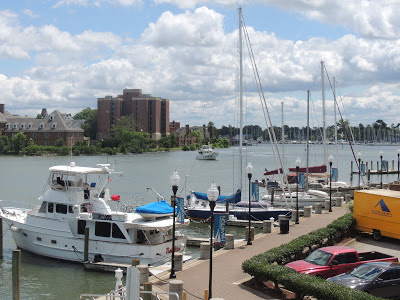
Needless to say, all our planning was now moot as most of the day had been spent waiting for the lock. Because of the delay our options had closed up somewhat so decided to bail out and find a marina. We had not been to Hampton before and it sounded interesting and so here we are. We arrived at 5 PM and tied up right in front of the Crowne Plaza Hotel, very posh.

Boats rolling in - note the tug & barge


Sitting down on the job


Nice and tight with the tug


Hammer head crane


George Bush


Hospital Ship


Today;s photo

Tuesday, June 11, 2013

Great Bridge, VA

Tuesday June 11, 2013
36 43.265 N
76 14.462 W

Looking towards the lifting bridge
Back in one of my favorite spots. We are tied up to the wall between the bridge and the lock. We step off the boat onto cut grass, and we get to wave at all the passing boats. . Plus there is a Mexican restaurant just up the road. Deidre is sitting on the aft deck reading a book. Its about 85 degrees.
Easy run today, maybe 35 miles. It was quite windy earlier in the day but just a breeze now. There are several opening bridges in this section so the boats tend to get a bit bunched up. We lined up with a dozen or so boats waiting for Great Bridge to open.

Let's go!!!
.
Today's photo


Monday, June 10, 2013

Coinjock marina

Monday June 10, 2013
36 21.102 N
75 56.856 W

The wind settled down overnight and eventually we got a good night's sleep. It was calm when we dragged ourselves out of bed in the AM but the sky looked quite threatening. The forecast indicated 90% chance of rain, which sorta summed it up.

Albemarle Sound seems to be a bit of an awkward location on the trip north -  Norfolk is too far away for one day and too close for two, and there are not a lot of decent anchorages in between. Therefore, especially since the weather is a bit crappy, we have decided to go only 30 miles to an inexpensive marina at a place called Coinjock. It's a bit in the middle of nowhere, but there is a restaurant that we will ride our bikes to.

"Let's go below"
The trip was uneventful except for thunder storms that rolled thru. We must have missed 90% of the rain from pure luck, but had to scurry down to the pilot house a couple of times. An advantage of being on the water is that you can see the rain coming - if you look.

We are now tied up with the air conditioning blasting away, and planning the bike ride. Its quite stormy outside, maybe we should take our umbrella?

The ride to the restaurant turned out to be a bit harder than expected. It was about 3 1/2 miles each way and involved riding/walking
Back from the bathrooms
over a very busy high clearance bridge. There was no sidewalk and so we walked our bikes in the narrow berm. Obviously we could not make the return trip in the dark so that restricted the time we had to eat. There were a lot of fancy boats on the other side (It was $0.25 a foot more expensive, hence we were on the "wrong side".) Dinner was forgettable. We made it home OK and immediately iced Deidre's ankle.

(PS: This morning I was pleased to see that Collingwood thrashed Melbourne. I hope Townsend was watching)

Sunday, June 9, 2013

Alligator River/Albermale Sound

Sunday June 9, 2013
35 54.747
75 57.963

Despite the heat we both seemed to sleep well. The morning was very humid with fog or mist. We got underway by 10 AM and enjoyed the cooler air up on the bridge.

The ICW passed thru some very primitive country. Both sides of the waterway were vast Cyprus swamps, as far as we could see. We had not internet or phone service. A couple of thunderstorms past overhead and we were in and out. There was very little traffic. Not a good spot to break down!

The forecast for tonight was 5 - 10 kt winds from the south. To avoid the heat of last night I picked a spot that is a bit exposed to the south, hoping we will get some breeze. But the wind has picked up and we are bouncing around and now I feel a bit too exposed. But the internet signal is quite strong.


Belhaven

Saturday June 8, 2013


We were back in the water at Bock by 9:00 AM. All I had to do was pay the bill and we were on our way.  We were tied to an old dock and Deidre and I reduced the lines down to two as we prepared to leave. I flipped off the bow and ran to the Pilothouse, Deidre flipped off the stern - but it did not flip! We were lose except that the stern line had jammed in a gap in the old lumber dock. There was lots of wind (left over from the day before) and quite a bit of current. This is not a nice situation and it took some scrambling to resolve..

The rest of the day was uneventful. We had wind and tide on our stern all day and averaged about 7.5 kts over 52 miles. We anchored in a very well protected harbor at Belhaven. As soon as we stopped the humidity hit us. At one point I went out the back door and let in a million insects. We attacked them with spray and in the AM we had so many bodies on the floor Deidre had to vacuum.

We were overtaken by a beautiful 54' Selene.

Selene


Bayliner just like our old boat

Wednesday, June 5, 2013

Bock Marine - NOT My Favorite Place! (Well maybe!)

Wednesday June 5, 2013
34 49.432 N
76 41.373 W

It's 1:30 PM, we just tied up at Bock, waiting fr the travel lift to pull us out. I employed a diver to clean and inspect the hull in Charleston and he reported that Tide Hiker had a big "blister" on the port stabilizer. So we have decided to pull in here to have it investigated. Not that Bock is my favorite place - quite the contrary - but sometimes "the devil you know etc..."

The black is stinking slimy mud
This morning we were up at 6 AM and underway 20 minutes later. We had arranged a "guaranteed" opening of the Onslow bridge at 7 AM and it was about 3 miles away. The anchor came up OK, but the chain was as filthy as I have ever seen. What a mess. I just could not put it into the locker the way it arrived and the dlay hosing it down was threatening the bridge schedule. But we made it OK and so made an early appearance here at Bock

On the way we called some friends who were renovating a boat in this area and they plan to pop in this afternoon which we be some compensation. At the moment we are just waiting for the crane.

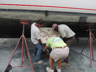
We were hoisted out at 2:30 PM and after a quick inspection decided to stay and get the fin repaired. There are several large "bubbles" on the fin where the fiberglass has de-laminated. The question now is "Can we get out of here quickly so we can maintain our schedule to the wedding in Chicago?"

Thursday June 6, 2013

The fin was removed first thing this morning and taken to the fiberglass shop. It is badly de-laminated. The "fiberglassman" has removed several large chunks of the surface. he says it has been repaired before - but not well. The yard is doing a great job getting this organized - I am impressed.

The fin coming off
The weather is adding another complication. Tropical Storm ANDREA has formed in the Gulf and is heading this way with heavy rain and 45 MPH wind. It should arrive here tomorrow evening, and so to some extent I am glad we are not on the water.

Deidre and I popped in on the glass man this afternoon. he had finished the first stage of the repair. he will let it "cure" tonight and complete the repair in the AM.


The de-lamination


Friday June 7, 2013

If you look carefully, the yellow bit will go right over us tomorrow night.


It rained pretty hard last night and its very windy today. I suspect we are seeing gusts over 50 MPH. It's noisy in here with all the yacht rigging 'singing" in the wind. Work in the yard is pretty much at a standstill, but the stabilizer fin did come back from the yard and is now installed. My opinion of BOCK MARINE has improved a lot. The plan is to put us back in the water tomorrow morning.


Tuesday, June 4, 2013

Mile Hammock

June 4, 2013
34 33 117 N
77 19 512 W

Back in October 2012 when we were making our way south thru the North Carolina ICW I vowed that from that point on I would never travel this section of the ICW again. But here we are again. It was just too rough to "go outside" this morning so we set off up the ICW and i got pissed off all over again.

"Look at me" house on the ICW
There has been a lot of progress over the last 10 years replacing opening bridges with high bridges, but not so much in NC. Between Wrightsville Beach and Beaufort there are still 4 opening bridges. To make matters worse, the powers to be in North Carolina have decided that car traffic has priority over water traffic (at least the ones that need the bridges to be opened) and so the bridge openings are restricted to essentially once per hour. Plus the bridge in the camp LeJeune is closed when the marines are playing with live ammo. We never made it thru the LeJeune bridge because the marines are on exercise and the bridge was "closed".

Osprey landing "just over there"
So we "gave up" and have anchored in dredged basin near the marine base - it was dredged in WW2 to be used to practice amphibious operations.We are told that one can typically hear the noise of the war games - in fact an "Osprey" just flew over the boat and landed in the bush 1/4 mile away. Interesting. Maybe we won't have to watch TV tonight!

I just called the Marine HQ about bridge opening tomorrow and they did not seem to be quite sure. And here I thought that after "sequestration" they could not afford any bullets.

Here is a video for those who can open it.


Monday, June 3, 2013

Wrightsville Beach, NC

Monday June 3, 2013
34 12.467 N
77 47.957 W

Easy day today. We were tired after 11 hours "at sea" yesterday so enjoyed a solid night's sleep last night with the AC  blasting. We were under way by 10.00 AM and anchored here by 1:45 PM. Only about 20 miles, all on the cape Fear River and the ICW. We are "staging" ourselves here because there is a reliable opening to the Atlantic where we can start our trip to Beaufort NC tomorrow, weather permitting.

The weather today is breezy with a lot of thunder storms around. It started to rain just as we were dropping the anchor. Its a great anchorage, well protected and close to downtown. We have a friend driving over to meet us for dinner. He is a fun guy and owns a boat like Tide Hiker and has installed a solar power system that I would like to emulate before we head out into the Caribbean.

Just after we settled in a beautiful Selene 54' pulled in and anchored behind us. We were meeting a friend here for dinner so we launched the dinghy and went ashore. Dinner was good! We have decided we like this anchorage and will return one day for a longer stay.

Snow's Cut

Nice Selene 54 behind us


I have also added a short video for those who can view them.


Sunday, June 2, 2013

South Port on the Cape Fear River

Sunday June 2nd, 2013
33 55.831 N
77 59.800 W

Big day today, 81 miles. We were up at 5:30  AM and underway by 6:05 AM. The forecast had deteriorated a bit overnight but is still seemed OK - winds 10/15 with gusts up to 20, waves 3' to 4' - so we headed out the entrance. We had a strong tide current and hit 9 knots on the way out.

Our evening at anchor had been fine. The anchor took hold first try and never moved..The anchorage was protected from the wind, but the interesting issue was the current that could run up to 2 1/2 knots, and reversed every 6 hours or so. Shortly after anchoring I could hear the props spinning in the current. Apparently, spinning like that is not good for the transmission so I spent 5 minutes in the ER and was able to jam both shafts with a couple of screwdrivers. (I left a lot of notes for the morning to take them out!). We were joined by a yacht later in the evening.

This was our first night on anchor for some time and it was really pleasant and we slept like logs. In Charleston I had "installed" 4 cheap solar lights on the boat deck. They only cost a few bucks each but are perfect for lighting the boat at anchor. They soak up the sun's rays all day and glow all night, all for about $5 each at Walmart. (We do have an anchor light but you can never have too many lights at night!)

The yacht pulled out about 30 minutes ahead of us. After we cleared the last light I called them on the radio and we had a chat. About this time Deidre got sick. The sea was not that rough but it was on our stern quarter and definitely "awkward". I felt so bad for her. She could not get comfortable.

We arrived at the Cape Fear light right on time at 4;00 PM and we were tied up in the marina by 5 PM. We were 'expected" to weave in and out and then back Tide Hiker into the slip in pretty tight quarters.

Nice parking job


Saturday, June 1, 2013

On the move again!

Wynyah Bay (Near Georgetown, SC)
33 15.504 N
79 14.988 W

Leaving IOP
Low tide was at 9:00 AM and the low was below mean low tide, so we decided to delay our departure until 10:00 AM. We did not have a long run planned so the decision created no stress. Ky and Ryan visited at about 9:45 AM to see us off and shed a few tears. We pulled out right at 10:00 AM and enjoyed some nice farewells from other boats at the marina. We were pleased to be on our way, but obviously quite sad to leave Ky and Ryan and little Mason!

We are now anchored in Wynyah Bay, about 5 miles from the Atlantic. The weather is great with 10 MPH wind from the south. If the wind comes up during the night we are sheltered by Cat Island. The current in and out of here is pretty strong (up to 2.6 kts) so that is more to think about than the wind. We plan to catch the tide in the AM and make a straight line to the Cape Fear River entrance, about 80 miles away. We will be up early.


Nordhavn 46
The trip was pretty uneventful. We enjoyed tidal current for 75% of the time so our speed was pretty good. We caught up with a Nordhavn 46' and had a bit of a chat but they did not want to go outside with us. There are a lot of horse flies in this area so after a while we retreated into the pilot house.